
Map of the Wisconsin Territory
Wisconsin Historical Images
On July 4, 1836, Wisconsin officially broke off from Michigan to become its own territory.
Michigan was one of several territories that the future Wisconsin had belonged. We’d been part of the original Northwest Territory, Indiana Territory, Illinois Territory, and finally Michigan before becoming a territory in our own right once enough people had settled here and Michigan became a state.
Land speculator, judge, and all-around Wisconsin booster James Duane Doty led the effort to create the Wisconsin territory. Much to Doty’s chagrin, President Andrew Jackson appointed his rival General Henry Dodge governor.
Doty didn’t let this setback deter him in his quest to shape Wisconsin. Dodge’s new job came with responsibility for conducting a census, holding elections, and convening a territorial legislature that would select a new capital. Doty purchased some land with a few partners on an isthmus where downtown Madison stands today. Doty then hired a surveyor who mapped out a hypothetical city that he named Madison after the former president who had just died and aggressively lobbied the legislature to select his planned city as capital. Out of 19 contenders, Doty won.
Doty finally became Wisconsin’s territorial governor in 1841, where he tried and failed to lobby public support for statehood.
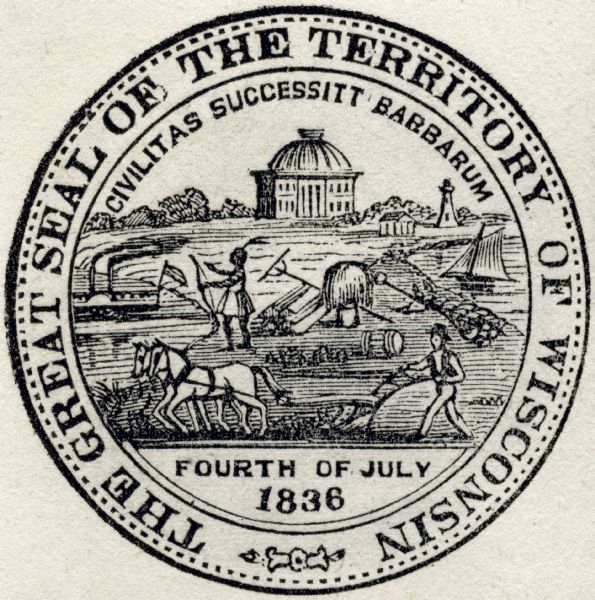
This territorial seal, likely created in 1838, shows a farmer plowing behind a horse, a Native American, a river steamboat, lighthouse, and lake schooner, and the first Madison capitol building (though not a very accurate representation of that).
Territorial Seal
Wisconsin Historical Images
